Architecture
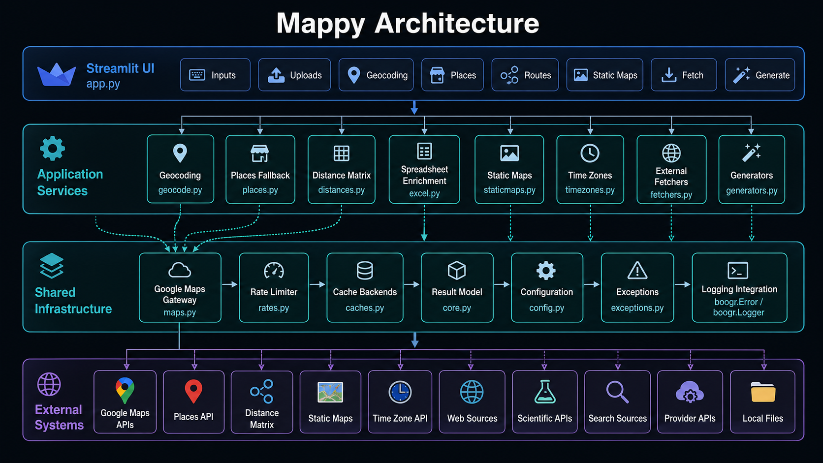
Mappy is a Python geospatial toolkit and Streamlit application for Google Maps workflows, location enrichment, route analysis, static map generation, external data retrieval, and generated-content workflows. The architecture is intentionally flat and service-oriented: each major capability lives in a standalone Python module that can be used directly from code or orchestrated through the Streamlit interface.
🧭 Architectural Overview
Mappy is organized around a reusable service layer with a Streamlit application on top. The application layer handles user interaction, while the service modules handle validation, external requests, normalization, caching, enrichment, and output generation.
+----------------------------------------------------------------------------------+
|                                  Streamlit UI                                     |
|                                    app.py                                         |
|----------------------------------------------------------------------------------|
|  Inputs | Uploads | Geocoding | Places | Routes | Static Maps | Fetch | Generate |
+---------------------------------------+------------------------------------------+
                                        |
                                        v
+----------------------------------------------------------------------------------+
|                              Application Services                                |
|----------------------------------------------------------------------------------|
|  Geocoding          Places Fallback       Distance Matrix      Spreadsheet        |
|  geocode.py         places.py             distances.py         excel.py           |
|                                                                                  |
|  Static Maps        Time Zones            External Fetchers    Generators         |
|  staticmaps.py      timezones.py          fetchers.py          generators.py      |
+---------------------------+----------------------+-------------------------------+
                            |                      |
                            v                      v
+----------------------------------------------------------------------------------+
|                              Shared Infrastructure                               |
|----------------------------------------------------------------------------------|
|  Google Maps Gateway      Rate Limiter        Cache Backends       Result Model   |
|  maps.py                  rates.py            caches.py            core.py        |
|                                                                                  |
|  Configuration            Exceptions          Logging Integration                 |
|  config.py                exceptions.py       boogr.Error / boogr.Logger          |
+---------------------------------------+------------------------------------------+
                                        |
                                        v
+----------------------------------------------------------------------------------+
|                              External Systems                                    |
|----------------------------------------------------------------------------------|
|  Google Maps APIs | Places API | Distance Matrix | Static Maps | Time Zone API    |
|  Web Sources      | Scientific APIs | Search Sources | Provider APIs | Local Files    |
+----------------------------------------------------------------------------------+
🧱 Design Principles
Mappy follows a few practical design principles.
| Principle | Description |
|---|---|
| Flat source layout | Modules sit at the repository root so the app and documentation can import them directly. |
| Thin UI layer | app.py should orchestrate workflows, not bury service logic inside Streamlit callbacks. |
| Reusable services | Geocoding, Places, Distance Matrix, Static Maps, Time Zone, Excel enrichment, fetchers, and generators can be used independently. |
| Canonical output shapes | Service wrappers normalize external payloads into predictable dictionaries, lists, dataframes, or URLs. |
| Cache-aware workflows | Repeated lookups can use in-memory or SQLite cache backends. |
| Documentation-ready source | Public classes, functions, and methods use Google-style docstrings for MkDocs and mkdocstrings. |
| Stable exception logging | Wrapped exceptions record module, cause, method, message, and traceback without logging sensitive runtime values. |
🗂️ Repository Layout
Mappy uses a flat application layout with documentation under docs/.
Mappy/
  app.py
  caches.py
  config.py
  core.py
  distances.py
  excel.py
  exceptions.py
  fetchers.py
  generators.py
  geocode.py
  maps.py
  places.py
  rates.py
  staticmaps.py
  timezones.py
  requirements.txt
  README.md
  mkdocs.yml
  docs/
    index.md
    architecture.md
    user-guide.md
    development.md
    github-pages.md
    api/
      index.md
      app.md
      caches.md
      config.md
      core.md
      distances.md
      excel.md
      exceptions.md
      fetchers.md
      generators.md
      geocode.md
      maps.md
      places.md
      rates.md
      staticmaps.md
      timezones.md
    assets/
      css/
        extra.css
      js/
        extra.js
🖥️ Application Layer
The application layer is implemented in app.py.
app.py provides the Streamlit interface for interactive workflows. It should remain focused on
page layout, controls, state management, service orchestration, and display logic.
Primary responsibilities include:
| Responsibility | Description |
|---|---|
| Page configuration | Configures the Streamlit page, title, icons, and layout. |
| Sidebar controls | Collects mode selections, configuration values, and workflow options. |
| Input capture | Accepts addresses, coordinates, files, prompts, provider options, and user settings. |
| Service orchestration | Calls geocoding, Places, distance, static map, time-zone, fetcher, and generator modules. |
| Result rendering | Displays dictionaries, tables, dataframes, maps, generated text, URLs, and status summaries. |
| Session state | Maintains state across Streamlit reruns without moving business logic into the UI. |
The UI layer depends on the service layer. The service layer should not depend on Streamlit.
app.py
  |
  +-- geocode.py
  +-- places.py
  +-- distances.py
  +-- staticmaps.py
  +-- timezones.py
  +-- excel.py
  +-- fetchers.py
  +-- generators.py
🗺️ Google Maps Gateway Layer
The Google Maps gateway is implemented in maps.py.
The Maps class centralizes outbound Google Maps Web Services requests. Instead of having every
service wrapper construct its own HTTP logic, service classes call Maps.request(...).
Service Wrapper
      |
      v
Maps.request(endpoint, params)
      |
      +-- validate endpoint and parameter inputs
      +-- apply request rate limiting
      +-- inject configured Google Maps API key
      +-- issue HTTP GET request
      +-- record diagnostics
      +-- retry transient failures
      +-- raise gateway errors for hard failures
      |
      v
Parsed JSON payload
The gateway layer supports these service wrappers:
| Wrapper | Module | Google API Family |
|---|---|---|
Geocoder |
geocode.py |
Geocoding API |
Place |
places.py |
Places Text Search and Place Details |
DistanceMatrix |
distances.py |
Distance Matrix API |
Timezone |
timezones.py |
Time Zone API |
📍 Geocoding Layer
The geocoding layer is implemented in geocode.py.
The Geocoder class resolves free-form addresses, reverse-geocodes coordinates, resolves structured
city/state/country values, and supports batch geocoding.
| Component | Purpose |
|---|---|
flatten_geocode(...) |
Converts raw Google Geocoding results into Mappy’s canonical output shape. |
Geocoder.freeform(...) |
Resolves one free-form address. |
Geocoder.reverse(...) |
Resolves one coordinate pair into an address. |
Geocoder.city_state_country(...) |
Resolves structured locality fields. |
Geocoder.batch_freeform(...) |
Processes multiple addresses with row-level status handling. |
Typical output fields include:
| Field | Description |
|---|---|
formatted_address |
Canonical formatted address. |
lat |
Latitude. |
lng |
Longitude. |
place_id |
Google place identifier. |
types |
Google result types. |
country_code |
Short country code. |
country_name |
Full country name. |
admin_level_1 |
State, province, region, or equivalent. |
admin_level_2 |
County or secondary administrative area. |
locality |
City or locality. |
postal_code |
Postal code. |
source |
Workflow source, such as geocode or reverse_geocode. |
query |
Original query value. |
🏢 Places Layer
The Places layer is implemented in places.py.
The Place class provides a fallback and enrichment path for named locations, businesses,
landmarks, institutions, and ambiguous user queries. It uses Places Text Search to find candidates
and Place Details to retrieve structured metadata.
| Component | Purpose |
|---|---|
Place.text_to_location(...) |
Resolves free text into a canonical location record. |
Place.place_details(...) |
Resolves a known place_id into detailed metadata. |
Place.search_candidates(...) |
Returns candidate Places results for review or disambiguation. |
Place.flatten_place_details(...) |
Converts Place Details into Mappy’s canonical output shape. |
Place.component_value(...) |
Extracts address components from Google payloads. |
Places output intentionally overlaps with geocoding output. It also includes additional fields such as:
| Field | Description |
|---|---|
name |
Place name. |
business_status |
Google business status when available. |
rating |
Google rating when available. |
user_ratings_total |
Number of user ratings when available. |
website |
Place website when available. |
formatted_phone_number |
Place phone number when available. |
🛣️ Distance Matrix Layer
The distance layer is implemented in distances.py.
The DistanceMatrix class wraps route-distance and duration workflows.
| Component | Purpose |
|---|---|
DistanceMatrix.matrix(...) |
Executes one-to-many or many-to-many distance requests. |
DistanceMatrix.summary(...) |
Returns a compact one-route summary. |
DistanceMatrix.compare_modes(...) |
Compares travel modes for the same route. |
DistanceMatrix.to_dataframe(...) |
Converts route rows into a pandas DataFrame. |
DistanceMatrix.normalize_mode(...) |
Validates travel mode values. |
DistanceMatrix.normalize_inputs(...) |
Normalizes address and coordinate inputs. |
DistanceMatrix.flatten_element(...) |
Converts one Google response element into a row. |
Supported modes are:
| Mode | Description |
|---|---|
driving |
Driving distance and duration. |
walking |
Walking distance and duration. |
bicycling |
Bicycling distance and duration. |
transit |
Transit distance and duration when available. |
🖼️ Static Maps Layer
The static map layer is implemented in staticmaps.py.
The StaticMap class builds Google Static Maps URLs. It does not download images directly. It
returns URLs that can be displayed in Streamlit, used in documentation, opened in a browser, or
embedded in reports.
| Component | Purpose |
|---|---|
StaticMap.pin(...) |
Builds a single-marker map URL. |
StaticMap.pins(...) |
Builds a multi-marker map URL. |
StaticMap.path(...) |
Builds a map URL with a visible path. |
StaticMap.bbox(...) |
Builds a map URL with a bounding box outline. |
StaticMap.build_url(...) |
Assembles the final Google Static Maps URL. |
StaticMap.normalize_points(...) |
Converts supported point shapes into coordinate tuples. |
StaticMap.validate_coordinate(...) |
Validates latitude and longitude ranges. |
🕒 Time Zone Layer
The time-zone layer is implemented in timezones.py.
The Timezone class wraps the Google Time Zone API.
| Component | Purpose |
|---|---|
Timezone.lookup(...) |
Retrieves the full Google Time Zone API payload. |
Timezone.get_id(...) |
Extracts the IANA time-zone identifier. |
Timezone.offset_hours(...) |
Calculates total UTC offset in hours. |
Timezone.local_time(...) |
Converts UTC time into local time for a coordinate. |
Timezone.batch_lookup(...) |
Enriches row dictionaries with time-zone fields. |
Timezone.validate_coordinates(...) |
Validates latitude and longitude ranges. |
📊 Spreadsheet Enrichment Layer
The spreadsheet layer is implemented in excel.py.
The Excel class reads CSV/XLSX files, resolves location data, appends canonical geospatial output
columns, summarizes enrichment results, and writes enriched files.
CSV/XLSX Input
      |
      v
Excel.read(...)
      |
      v
Row iteration
      |
      +-- Geocoder.freeform(...)
      |       |
      |       +-- fallback to Place.text_to_location(...)
      |
      +-- Geocoder.city_state_country(...)
              |
              +-- fallback to Place.text_to_location(...)
      |
      v
Canonical enrichment columns
      |
      v
Excel.write(...)
      |
      v
CSV/XLSX Output
The enrichment layer preserves row alignment. Every input row receives output values, even when the row is skipped, not found, or fails with an error.
Common row-level status values include:
| Status | Meaning |
|---|---|
ok |
Resolved through geocoding. |
ok_places |
Resolved through Places fallback. |
not_found |
No usable result was found. |
skipped_empty |
The source row did not contain usable location input. |
error |
A row-level error occurred. |
🧠 Cache Layer
The cache layer is implemented in caches.py.
Caching reduces duplicate lookups and allows repeated workflows to reuse previous results.
| Class | Storage | Purpose |
|---|---|---|
BaseCache |
Interface | Defines the common cache contract. |
InMemoryCache |
Python dictionary | Provides fast process-local caching. |
SQLiteCache |
SQLite database | Provides durable local caching across application runs. |
Cache implementations support:
| Method | Purpose |
|---|---|
get(...) |
Read a cached dictionary payload. |
set(...) |
Store a cached dictionary payload. |
delete(...) |
Remove one cached key. |
clear(...) |
Clear all records or a namespace. |
contains(...) |
Check whether a usable cached value exists. |
stats(...) |
Return backend diagnostics. |
⏱️ Rate Limiting Layer
The rate-limiting layer is implemented in rates.py.
The RateLimiter class enforces a minimum interval between requests. The Maps gateway calls it
before outbound API requests.
Maps.request(...)
      |
      v
RateLimiter.wait()
      |
      +-- count request
      +-- compare elapsed time with configured interval
      +-- sleep when necessary
      +-- update diagnostics
📦 Core Model Layer
The core layer is implemented in core.py.
The Result class wraps an HTTP response into a lightweight result object.
| Field | Description |
|---|---|
url |
Response URL. |
status_code |
HTTP response status code. |
text |
Response text body. |
encoding |
Response encoding. |
headers |
Response headers. |
response |
Original requests.Response object. |
🌐 Fetcher Layer
The fetcher layer is implemented in fetchers.py.
Fetchers isolate retrieval logic for web pages, documents, search results, scientific sources, environmental sources, geospatial services, and other external data sources.
User or App Request
      |
      v
Fetcher Class
      |
      +-- validate inputs
      +-- call external source
      +-- parse or normalize result
      +-- return text, data, document, table, image, or result object
The architectural role of fetchers.py is to keep external retrieval logic out of the Streamlit UI
and out of generator classes.
✍️ Generator Layer
The generator layer is implemented in generators.py.
Generators transform prompts, retrieved context, user inputs, files, or structured data into generated responses or structured outputs.
Prompt / Context / Data
      |
      v
Generator Class
      |
      +-- validate inputs
      +-- prepare provider payload
      +-- call provider or local model
      +-- normalize output
      |
      v
Generated response or structured result
The architectural role of generators.py is to keep provider-specific generation logic separate
from the UI and retrieval layers.
⚠️ Exception Layer
Project-specific exceptions are defined in exceptions.py.
| Exception | Purpose |
|---|---|
MappyError |
Base exception for known Mappy errors. |
GatewayError |
External gateway, API, response, retry, or transport failure. |
NotFound |
Lookup completed without producing a usable result. |
Operational modules that wrap errors use the project logging pattern:
The logging pattern records stable diagnostic metadata, such as module, cause, method, message, and traceback. Runtime-sensitive values should not be written to logs.
Do not log:
| Sensitive Value | Reason |
|---|---|
| API keys | Secret credential. |
| Raw payloads | May contain user input or provider data. |
| Full API responses | May contain user or service data. |
| Addresses | User-provided location data. |
| Coordinates | User-provided location data. |
| File contents | Uploaded data may be sensitive. |
| DataFrame rows | Uploaded spreadsheet rows may contain sensitive data. |
| Cache keys | Cache keys may include normalized user input. |
🔐 Configuration Layer
Configuration is centralized in config.py.
Typical configuration responsibilities include:
| Area | Purpose |
|---|---|
| Paths | Root, log, database, image, and documentation paths. |
| API keys | External provider keys read from environment variables. |
| App labels | Application title, subtitle, and UI constants. |
| Helper functions | Typed environment-variable readers and validation helpers. |
The configuration layer should not perform external network work. It should remain safe to import.
🔄 Primary Data Flow
Most workflows follow the same pattern.
User Input
   |
   v
Streamlit UI or Python Caller
   |
   v
Service Wrapper
   |
   +-- validate inputs
   +-- check cache when configured
   +-- call gateway, fetcher, or provider
   +-- normalize result
   +-- write cache when configured
   |
   v
Dictionary / DataFrame / URL / Generated Output
   |
   v
Display, export, documentation, or downstream use
🧩 Extension Points
Mappy is designed so additional workflows can be added without rewriting the whole application.
| Extension | Where to Add It |
|---|---|
| New Google Maps service | Add a service wrapper that uses Maps.request(...). |
| New external data source | Add a fetcher class in fetchers.py. |
| New generation provider | Add a generator class in generators.py. |
| New enrichment column | Extend Excel.create_outputs(...), append_empty(...), and append_result(...). |
| New cache backend | Implement the BaseCache interface. |
| New Streamlit workflow | Add UI orchestration in app.py that calls an existing service class. |
| New API documentation page | Add docs/api/<module>.md with a mkdocstrings directive. |
📚 Documentation Integration
Mappy documentation is built with MkDocs, Material for MkDocs, and mkdocstrings.
Source modules are documented with Google-style docstrings. API pages under docs/api/ should use
mkdocstrings directives such as:
The documentation system depends on:
| File | Purpose |
|---|---|
mkdocs.yml |
Site configuration, navigation, theme, and plugin settings. |
docs/index.md |
Documentation landing page. |
docs/architecture.md |
Architecture explanation. |
docs/user-guide.md |
Usage guide and examples. |
docs/development.md |
Contributor and validation guide. |
docs/api/*.md |
API reference pages generated from source docstrings. |
docs/assets/css/extra.css |
Documentation styling overrides. |
docs/assets/js/extra.js |
Small documentation UI enhancements. |
✅ Architecture Summary
Mappy’s architecture is organized around clear separation of responsibilities:
| Layer | Main Files | Responsibility |
|---|---|---|
| UI | app.py |
User interaction and workflow orchestration. |
| Service wrappers | geocode.py, places.py, distances.py, staticmaps.py, timezones.py, excel.py |
Domain workflows and normalized outputs. |
| Gateway | maps.py |
Shared Google Maps request execution. |
| Infrastructure | caches.py, rates.py, core.py, config.py, exceptions.py |
Caching, rate limiting, configuration, models, and errors. |
| Retrieval | fetchers.py |
External data retrieval. |
| Generation | generators.py |
Generated content and provider workflows. |
| Documentation | docs/, mkdocs.yml |
MkDocs site and API reference. |